|
|

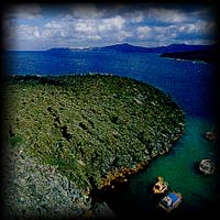 In a terrible eruption, 3.600 years ago,the Strongyli volcano collapsed,creating the huge cauldron of the caldera we see today.
The Santorini island complex, the island of Thira, Thirasia, and Aspronisi, are the fragments tha remained above the surface of
the sea after the collapse, while the rest,the greatest portion of the island, dissapeared under the water.
Not long after the caldera was formed, molten rock, viscous magma
with few gases, again began to flow up in the center of it, solidifying in
contact with the seawater and thus slowly building up a submarine volcanic
structure which would eventually become the foundation of the Kameni
islets. This activity was not recorded by the ancient historians, and was very
likely not observed by the people then living on the island.
In a terrible eruption, 3.600 years ago,the Strongyli volcano collapsed,creating the huge cauldron of the caldera we see today.
The Santorini island complex, the island of Thira, Thirasia, and Aspronisi, are the fragments tha remained above the surface of
the sea after the collapse, while the rest,the greatest portion of the island, dissapeared under the water.
Not long after the caldera was formed, molten rock, viscous magma
with few gases, again began to flow up in the center of it, solidifying in
contact with the seawater and thus slowly building up a submarine volcanic
structure which would eventually become the foundation of the Kameni
islets. This activity was not recorded by the ancient historians, and was very
likely not observed by the people then living on the island.
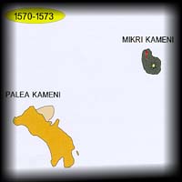
PALEA KAMENI
THE ERUPTION OF 46-47
A.D
About 200 years later, towards the end
of the year 46 and the beginning of the year 47 A.D., the volcano re-
awakened. Huge quantities of viscous molten rock (magma) spouted out of
the sea two kilometers southwest of lera, creating the islet of Palea Kameni.
At that time the islet, which was known as Thia, had a circumference of 5,550
meters, as the Roman historian Aurelius Victor registers in his work Historia
Romana. It gradually acquired its present shape through fragmentation by
great cracks and faults and the collapse of its shoreline in many places.
THE ERUPTION OF
726
During the next seven centuries the volcano
remained quiescent. It became active again in the year 726, this time
extremely violently. Several explosive events spewed pumice and volcanic
ash several kilometers into the air, sending it drifting across the Aegean
and into Asia Minor, as Theophanes the chronicler recorded:
"In the summer of that same year of the eighth "Indiction"', steam as
from a fiery furnace bubbled up from the depths of the sea between the
islands of Thira and Thirasia for several days, and in a short while, after it
had increased and hardened by the furious heat of the blazing fire, the
smoke began itself to seem like fire, and on account of the thickness of this
solid matter, large pumice stones were spewed out all over Asia Minor and
Lesbos and Abydos and towards those parts of Macedonia which overlook
the sea".
This eruption seriously disrupted the economic and social life of the
Aegean, and was interpreted as an indication of the wrath of God caused by
the Iconoclastic Controversy which was then lacerating the Byzantine
Empire.
Great quantities of volcanic tephra spewed out in this eruption can still
be seen on Palea Kameni. The viscous magma which later filled the crater
now appears as a black tongue of lava with a rough scoriaceous surface on
the northeastern shore of Palea Kameni, forming the north side of the bay of
Aghios Nikolaos.
NEA KAMENI
THE FIRST ERUPTION
(1570-1573)
 After the violent explosive eruption
of 726, no further sub-aerial volcanic activity was recorded for more than 800
years. But the volcano struck again in 1570. From an area near the "Bankos"
reef (the remnant of the islet of lera), flowed viscous magma punctuated by
numerous explosions. This activity continued for approximately three years,
creating a small dome-shaped island with a diameter of about 400 m. and a height of 70 m.,which
was called "Mikri Kameni" (Litle Burnt Island).The summit of the dome is occupied by a crater about 20
meters deep.
After the violent explosive eruption
of 726, no further sub-aerial volcanic activity was recorded for more than 800
years. But the volcano struck again in 1570. From an area near the "Bankos"
reef (the remnant of the islet of lera), flowed viscous magma punctuated by
numerous explosions. This activity continued for approximately three years,
creating a small dome-shaped island with a diameter of about 400 m. and a height of 70 m.,which
was called "Mikri Kameni" (Litle Burnt Island).The summit of the dome is occupied by a crater about 20
meters deep.
THE ERUPTION OF
1707-1711
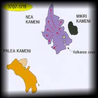 One hundred and thirty-tive years ot
quiescence followed before the volcano next showed signs of activity. The
initial signals took the form of minor seismic events on May 18 and 21,
1707. Two days later the inhabitants of Santorini watched the sea floor to
the west of Mikri Kameni slowly rise to the surface and become an islet,
bringing with it great quantities of shells, which the more daring among
them gathered. The new islet was called Aspronisi (White Island), because
the land that had arisen from the bottom of the sea was white with pumice.
A week later, the viscous magma made its appearance to the north of
Aspronisi. This new islet, formed of black chilled lava, was called Mavronisi
(Black Island).
A few days later there began a series of explosive eruptions, spewing
tephra and lava fragments to a height of up to two kilometers. This volcanic
activity continued for more than four years, and, by September 1711 had
created alongside Mikri Kameni a new island which became known as Nea
Kameni (New Burnt Island). The northeastern shore of the islet, and parti-
cularly the shores of a little bay known as Vulcanos Cove, quickly became
dotted with tiny churches and small buildings for the use of the people of
Santorini who came to the island to soak in the thermal springs with which
the coast abounded. They were also used by the fishermen who used to
bring their boats into the warm water to clean their bottoms, for the ferrous
and sulphurous hydrothermal solutions kill the accumulated parasites.
One hundred and thirty-tive years ot
quiescence followed before the volcano next showed signs of activity. The
initial signals took the form of minor seismic events on May 18 and 21,
1707. Two days later the inhabitants of Santorini watched the sea floor to
the west of Mikri Kameni slowly rise to the surface and become an islet,
bringing with it great quantities of shells, which the more daring among
them gathered. The new islet was called Aspronisi (White Island), because
the land that had arisen from the bottom of the sea was white with pumice.
A week later, the viscous magma made its appearance to the north of
Aspronisi. This new islet, formed of black chilled lava, was called Mavronisi
(Black Island).
A few days later there began a series of explosive eruptions, spewing
tephra and lava fragments to a height of up to two kilometers. This volcanic
activity continued for more than four years, and, by September 1711 had
created alongside Mikri Kameni a new island which became known as Nea
Kameni (New Burnt Island). The northeastern shore of the islet, and parti-
cularly the shores of a little bay known as Vulcanos Cove, quickly became
dotted with tiny churches and small buildings for the use of the people of
Santorini who came to the island to soak in the thermal springs with which
the coast abounded. They were also used by the fishermen who used to
bring their boats into the warm water to clean their bottoms, for the ferrous
and sulphurous hydrothermal solutions kill the accumulated parasites.
THE ERUPTION OF 1866-1870
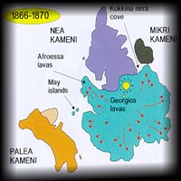 The dormant stage which followed
lasted for 155 years. It was finally interrupted on January 14, 1866 by a
series of seismic events which continued over a period of two weeks. The
waters of the eastern shore of Nea Kameni became noticeably warmer, and
the sea was coloured by fluids seeping from the magma which had begun to
rise. The buildings around Vulcanos Cove slowly began to sink into the sea.
On February 4, the first lavas appeared in the middle of the cove, and
two days later the eruptions began. They gradually increased in number and
intensity, sending lava fragments to a distance of more than 700 meters.
These ejecta frequently caused damage to the fishing boats that dotted the
waters around the islands, while the volcanic gases and the ash that were
ejected from the volcano caused problems for the inhabitants of Santorini and
the neighbouring island of Anafi.
The volcanic activity continued until October 15, 1870, mainly in the
form of effusion of fluid and extrusion of viscous lava. Besides the center in
Vulcanos Cove (which was named Georgios, in honour of the reigning King
of Greece, George I), two other centers produced lava flows and domes: these were
Aphroessa, 400 meters to the southwest of Georgios, and the
two Islets of May, which rose to the surface between Palea and Nea Kameni
in May of 1866. These two islets later subsided, and today are about one
meter below the surface of the sea.
The quantities of lava that were produced during this period (140
million cubic meters) tripled the size of Nea Kameni. A small strip of sea
continued to separate Mikri from Nea Kameni. This area became known as
Kokkina Nera (Red Waters) because the waters of the thermal springs that
abounded there left deposits of red oxidised iron on the shore, just as they
still do around Nea and Palea Kameni.
The dormant stage which followed
lasted for 155 years. It was finally interrupted on January 14, 1866 by a
series of seismic events which continued over a period of two weeks. The
waters of the eastern shore of Nea Kameni became noticeably warmer, and
the sea was coloured by fluids seeping from the magma which had begun to
rise. The buildings around Vulcanos Cove slowly began to sink into the sea.
On February 4, the first lavas appeared in the middle of the cove, and
two days later the eruptions began. They gradually increased in number and
intensity, sending lava fragments to a distance of more than 700 meters.
These ejecta frequently caused damage to the fishing boats that dotted the
waters around the islands, while the volcanic gases and the ash that were
ejected from the volcano caused problems for the inhabitants of Santorini and
the neighbouring island of Anafi.
The volcanic activity continued until October 15, 1870, mainly in the
form of effusion of fluid and extrusion of viscous lava. Besides the center in
Vulcanos Cove (which was named Georgios, in honour of the reigning King
of Greece, George I), two other centers produced lava flows and domes: these were
Aphroessa, 400 meters to the southwest of Georgios, and the
two Islets of May, which rose to the surface between Palea and Nea Kameni
in May of 1866. These two islets later subsided, and today are about one
meter below the surface of the sea.
The quantities of lava that were produced during this period (140
million cubic meters) tripled the size of Nea Kameni. A small strip of sea
continued to separate Mikri from Nea Kameni. This area became known as
Kokkina Nera (Red Waters) because the waters of the thermal springs that
abounded there left deposits of red oxidised iron on the shore, just as they
still do around Nea and Palea Kameni.
THE ERUPTION OF 1925-1928
 A series of minor seismic events on July
28, 1925 warned the inhabitants of Santorini that the volcano was waking
after a dormant period of 55 years. The sea around Kokkina Nera changed
colour and became noticeably warmer, and the eastern shore of Nea Kameni
once again began to subside.
The eruption, heralded by tremendous fountains of steam and water in
the area of Kokkina Nera, began on August 11, 1925. The fountains rapidiy
became explosive columns ejecting lava and volcanic ash. A few days later
the center of volcanic activity moved 200 meters to the southwest to a site
which today has several (at least 5) craters grouped together. These craters
and the pyroclastic cones of lava fragments which made them were created
by the volcanic activity of 1925. During that period, volcanic ash was
spewed to a height of more than 3,200 meters and lava fragments rained
over an area with a radius of more than 850 meters. Victor Akylas describes
one of these eruptions in his book entitled "The Volcanoes and the Island of
Thira". A series of minor seismic events on July
28, 1925 warned the inhabitants of Santorini that the volcano was waking
after a dormant period of 55 years. The sea around Kokkina Nera changed
colour and became noticeably warmer, and the eastern shore of Nea Kameni
once again began to subside.
The eruption, heralded by tremendous fountains of steam and water in
the area of Kokkina Nera, began on August 11, 1925. The fountains rapidiy
became explosive columns ejecting lava and volcanic ash. A few days later
the center of volcanic activity moved 200 meters to the southwest to a site
which today has several (at least 5) craters grouped together. These craters
and the pyroclastic cones of lava fragments which made them were created
by the volcanic activity of 1925. During that period, volcanic ash was
spewed to a height of more than 3,200 meters and lava fragments rained
over an area with a radius of more than 850 meters. Victor Akylas describes
one of these eruptions in his book entitled "The Volcanoes and the Island of
Thira".
"Nothing can compare with the superb eruption of August 19th,when
at about 3 o'clock in the afternoon there was a tremendous roar; a huge
cloud of steam darkened the whole surrounding area, volcanic ash spewed
with terrific force several kilometers into the air, while glowing fragments of
lava rained over an area 3,000 meters in diameter all around the Dafni
crater. This was followed by heavy showers of volcanic ash."
The explosive activity was accompanied by the ejection of huge
quantities of lava - an estimated 100 million cubic meters – which flowed in
two broad branches, one to each side of Mikri Kameni, filling the channel
separating it from Nea Kameni and adding substantially to the land surface
of the isiand which had now become a single mass. The name Daphni was
given to the lava flows and the craters in honour of the first war ship to
arrive on the scene immediately after the eruption.
This period of activity lasted for two years, until May 1926. The volcano
did reawaken briefly during the first three months of 1928, creating a small
lava dome to the east of the Daphni craters which was baptised Nautilus.
This dome, however, is no longer visibie for it was covered by lava produced
during the next stage of activity.
THE ERUPTION OF 1939-1941
 After a period of quiesence of only 11
years, the volcano awoke once again. Early in May 1939, it was observed that
the waters in the little bay of Aghios Georgios with its chapel dedicated to St
George, were heating up, and the coastiine was subsiding. A submarine
explosion at the harbour entrance on August 20, cleared the vent for the new
magma which began to appear, creating a small dome which the
volcanologists of the time promptly baptised "Triton" after the mythological
merman who used to rise up out of the sea.
One month later, the focus of volcanic activity shifted a few hundred
meters to the northeast where it created lava flows and a dome which were
given the name of "Ktenas" after a geologist who studied the Kameni
eruptions. This lava filled the little harbour of Aghios Georgios and covered the
Triton dome.
Between November 1939 and July 1940, the volcanic activity shifted
even farther to the northeast, creating the Fouque lava flows and dome,
named after the distinguished French naturalist who studied Santorini and
the eruptions of Kameni up until 1866.
In July 1940, two new centers of activity appeared to the south of the
Fouque center. The first was called Smith, after an American; and the second
Reck, after a German, voicanologist, both of whom had studied the 1925
eruptions. These centers produced lava domes and flows which covered the
western slopes of the now single island of Nea Kameni and flowed into the sea.
The explosive activity of this period was not severe, and the height to
which volcanic ash was ejected did not exceed 1,200 meters.
Late in August 1940, two major explosions from the summit of the island
blew the old rock plug from 1866 into the air, opening two large craters each
50 meters across. These are the craters which visitors to the isiand go to see
today. There was no magma outflow from these craters.
Towards the end of November of that same year, viscous lava began to
flow from a vent a bare 100 meters to the east, creating the lava fields
named "Niki" (Victory), in honour of the Greek victories in Albania. The lava
covered the eastern slopes of the isiand, stopping just short of the sea. This
period of activity lasted until July 1941. After a period of quiesence of only 11
years, the volcano awoke once again. Early in May 1939, it was observed that
the waters in the little bay of Aghios Georgios with its chapel dedicated to St
George, were heating up, and the coastiine was subsiding. A submarine
explosion at the harbour entrance on August 20, cleared the vent for the new
magma which began to appear, creating a small dome which the
volcanologists of the time promptly baptised "Triton" after the mythological
merman who used to rise up out of the sea.
One month later, the focus of volcanic activity shifted a few hundred
meters to the northeast where it created lava flows and a dome which were
given the name of "Ktenas" after a geologist who studied the Kameni
eruptions. This lava filled the little harbour of Aghios Georgios and covered the
Triton dome.
Between November 1939 and July 1940, the volcanic activity shifted
even farther to the northeast, creating the Fouque lava flows and dome,
named after the distinguished French naturalist who studied Santorini and
the eruptions of Kameni up until 1866.
In July 1940, two new centers of activity appeared to the south of the
Fouque center. The first was called Smith, after an American; and the second
Reck, after a German, voicanologist, both of whom had studied the 1925
eruptions. These centers produced lava domes and flows which covered the
western slopes of the now single island of Nea Kameni and flowed into the sea.
The explosive activity of this period was not severe, and the height to
which volcanic ash was ejected did not exceed 1,200 meters.
Late in August 1940, two major explosions from the summit of the island
blew the old rock plug from 1866 into the air, opening two large craters each
50 meters across. These are the craters which visitors to the isiand go to see
today. There was no magma outflow from these craters.
Towards the end of November of that same year, viscous lava began to
flow from a vent a bare 100 meters to the east, creating the lava fields
named "Niki" (Victory), in honour of the Greek victories in Albania. The lava
covered the eastern slopes of the isiand, stopping just short of the sea. This
period of activity lasted until July 1941.
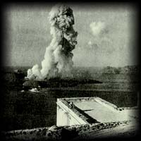
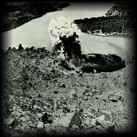
THE LAST ERUPTION ON SANTORINI (1950)
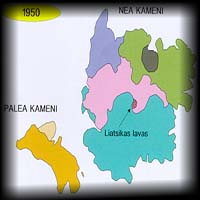 The most recent
volcanic eruption in Greece was that which shook Santorini early in January,
1950. There had been advance warning in the form of seismic events since
the previous August. On January 10, 1950, an explosion blew the oid rock
plug to the southern foot of the Niki dome, opening a vent for the new
magma which began to pour out. This was punctuated by intense explosive
activity which spewed tephra 1000 meters into the air, and dropped lava
fragments within a range of 850 meters ali around. The explosions and the
effusion of magma continued untii February 2, creating the youngest
volcanic rocks in Greece, the "Liatsikas lavas", named in honour of another
eminent geologist who studied the Kamenis. The most recent
volcanic eruption in Greece was that which shook Santorini early in January,
1950. There had been advance warning in the form of seismic events since
the previous August. On January 10, 1950, an explosion blew the oid rock
plug to the southern foot of the Niki dome, opening a vent for the new
magma which began to pour out. This was punctuated by intense explosive
activity which spewed tephra 1000 meters into the air, and dropped lava
fragments within a range of 850 meters ali around. The explosions and the
effusion of magma continued untii February 2, creating the youngest
volcanic rocks in Greece, the "Liatsikas lavas", named in honour of another
eminent geologist who studied the Kamenis.
The Volcano of Santorini
|


)